Prince Edward Island rewards patience. Fog lifts to reveal blue on blue—sky and Gulf—and then, twenty minutes later, a breeze slides in and changes the mood again. If you’re planning a trip, a move, or simply trying to time a potato harvest, understanding PEI weather is everything. This in-depth guide walks you through the Island’s climate month by month, explains why storms behave the way they do, and translates forecasts into practical choices—what to wear, when to drive, how to plan beach days, and how to prepare for Atlantic Canada’s famous nor’easters.
We’ll cover the seasons in detail, show typical temperatures and rainfall, unpack wind, fog, sea ice, and water temperatures, and add real-world tips Island residents actually use. Whether you’re eyeing Cavendish in July, a Charlottetown fall weekend, or a winter of snow and quiet, you’ll find clear, Canada-specific guidance right here.
The Big Picture: How the Gulf Shapes PEI Weather
Prince Edward Island sits in the Gulf of St. Lawrence, a shallow, semi-enclosed arm of the Atlantic bounded largely by the Maritimes and Newfoundland. That geography gives the Island a maritime climate—moderated by water yet shaped by fast-moving systems that sweep in from the continent. The Gulf is the main character here.
In winter, sea ice forms in the Gulf and the Northumberland Strait. Ice shields the shore from waves and limits evaporation, which can dull the edge of lake-effect-like snow bands that sometimes set up across the Strait. When the Gulf is ice-free and cold air pours over it, snow squalls can blossom and bury a few lucky (or unlucky) communities while others stay clear. As the climate warms, winter sea ice has been less reliable and shorter-lived, which affects storm surge and coastal erosion during winter storms.
In summer, the same shallow water warms quickly. The Northumberland Strait—between PEI and Nova Scotia/New Brunswick—often has some of the warmest ocean swimming in Canada by late July and August. Warm water breeds sea breezes. By midday, wind often turns onshore along the north and south coasts, knocking a couple of degrees off air temperatures right at the beach while Charlottetown basks in heat a few kilometres inland.
Because the Island is small, forecasts can feel hyperlocal. Wind direction makes a real difference. On hot days with a south wind, the south shore feels a touch cooler; with a north wind, beaches in the PEI National Park can trade heat for surf and a sweatshirt. If you’re used to continental interiors, think of PEI’s weather as a dialogue between land and water—lively, quick to shift, and rarely boring.
PEI Weather by Season
Winter on Prince Edward Island (December to February)
Winter arrives decisively, though not always on schedule. Typical daytime highs hover a few degrees below freezing, with nights that regularly dip into the negative double digits Celsius. Charlottetown’s long-term normals show January as the coldest month. That said, warm fronts can bring mid-winter thaws and freezing rain, and then a flash freeze behind the next cold front locks everything up again. Freeze–thaw cycles are part of PEI’s character—watch for black ice in shaded spots and potholes that grow overnight.
Snow is plentiful. Nor’easters—large, moisture-laden winter storms that ride up the Atlantic coast—can slam the Island with heavy snow, mixed precipitation, and fierce winds. Blizzards happen. Blowing and drifting snow can turn open rural roads into mazes of white with zero visibility. Power outages are not rare, especially when heavy, wet snow or ice coats trees and lines. If you’re new to the Island, you’ll quickly learn to keep the pantry stocked, devices charged, and a flashlight where you can find it. Maritime Electric maintains an outage map and restoration updates, and the PEI Emergency Measures Organization shares preparedness advice when storms threaten.
Another winter piece is wind chill. A day that reads -7°C can feel like -15°C when a stiff northwester is running down the Strait. Dress for the wind, not just the thermometer: windproof outer layers, toque, insulated boots with traction, and mitts beat gloves for warmth. For driving, winter tires are strongly recommended across Atlantic Canada; while Quebec legally mandates them each winter, PEI does not—yet anyone who spends a season here will tell you they’re essential for control and braking on packed snow and freeze–thaw ice.
Spring on PEI (March to May)
Spring is a slow burn. March and even early April still feel wintry, and the landscape flips between slush and glare ice. As sun angles climb, snowpack rots from underneath and ditches run with meltwater. Rural roads soften and ruts appear; on gravel, this is mud season. Municipalities and the province post weight restrictions for heavy trucks to protect roads, and some trail networks stay closed to avoid damage.
By late April and May, the Island greens quickly—if the wind co-operates. Sea-surface temperatures are still cold, so persistent onshore winds can keep coastal areas sweater-cool even when inland spots feel like spring. Fog is occasional, not as relentless as along the Bay of Fundy, but on days when warm air crosses cold water, expect sea fog near harbours and beaches. Gardeners watch the last frost dates closely; most of PEI is in plant hardiness zones roughly 5b to 6a, with typical last spring frosts landing in late May or early June. If you plant early, keep frost cloth handy for those crystal-clear nights after a front passes.
Summer on PEI (June to August)
Summer is what most visitors dream about: warm days, cool nights, and beaches that invite you in. Typical daytime highs float in the low to mid-20s Celsius, with many blue-sky days and fewer thunderstorms than central Canada. Humidity spikes happen but tend to be short-lived; when humidex values climb into the low 30s, a sea breeze often breaks the heat by afternoon, especially along the north shore. After supper, a light jacket appears as temperatures ease.
Water temperatures peak later than air. Even if June starts toasty, the Gulf takes time to warm. Beach season really finds its stride in late July and August, when the Northumberland Strait can reach the low 20s Celsius, easily among the warmest ocean swimming temperatures in Canada. That warm water also feeds patchy morning fog that burns off by midday. Thunderstorms do occur—usually on frontal passages—but they’re less frequent and less severe than storms on the Prairies or in southern Ontario. Lightning safety still applies: when thunder roars, head indoors or into a hard-topped vehicle.
Summer also brings festivals and tourism traffic. The Cavendish Beach Music Festival, Charlottetown’s busy calendar, and full campgrounds mean PEI weather turns into a planning tool: check wind direction for your beach choice, use the UV index to time mid-day shade, and carry a light layer for evening concerts near the shore. Sunscreen and hats aren’t optional. UV can be high even when the air feels mild.
Fall on PEI (September to November)
September might be the Island’s best-kept secret. The water is still warm, crowds thin, and days are comfortable, often in the high teens to low 20s. By late September and October, maples paint backroads, nights grow crisp, and the smell of potatoes being dug drifts across the countryside. PEI’s famous red soil sticks to boots after rain; keep an extra floor mat in your car.
Fall also coincides with Atlantic hurricane season’s peak. PEI doesn’t get classic hurricanes with tropical structure very often, but it does see the remnants and post-tropical transitions of storms that curve north. These systems can bring intense rainfall, long-duration winds, and coastal storm surge, as seen dramatically during post-tropical storm Fiona in 2022. Environment and Climate Change Canada (ECCC) issues tropical cyclone statements and storm surge warnings when needed. As the calendar leans into November, nor’easter season returns, and those first wet snowfalls test gutters, trees, and patience. First frosts typically land late September to early October; gardeners race the clock with pumpkins, tomatoes, and dahlias.
PEI Weather by Month: What to Expect
Exact conditions vary year to year, but the table below gives a practical sense of monthly patterns in Charlottetown and coastal areas. Use it to time trips and set expectations. The ranges reflect the Island’s maritime swings and microclimates.
| Month | Typical Daytime High (°C) | Typical Nighttime Low (°C) | Precipitation Tendency | Snow Likelihood | Daylight (approx.) | Notes |
|---|---|---|---|---|---|---|
| January | -6 to -1 | -14 to -8 | Frequent systems; mix of snow and occasional freezing rain | High | 8–9 hours | Blizzards possible; strong NW winds and wind chill |
| February | -5 to -1 | -13 to -8 | Active storm track; some cold snaps | High | 10 hours by late month | Sea ice presence varies by year |
| March | -1 to 4 | -9 to -3 | Frequent transitions; rain–snow mix | Moderate to high | 11–12 hours | Freeze–thaw becomes common; icy mornings |
| April | 6 to 10 | -2 to 3 | Showers; a late snow not unheard of | Low to moderate | 13–14 hours | Coastal fog on warm days over cold water |
| May | 12 to 17 | 3 to 8 | Showers, some longer sunny stretches | Low | 14.5–15.5 hours | Sea breezes keep beaches cooler |
| June | 18 to 22 | 8 to 12 | Light to moderate rainfall; thunderstorms occasional | Very low | 15.5–16 hours | Water still cool; blackflies early in the month |
| July | 21 to 25 | 12 to 16 | Scattered showers; some humid spells | None | 15–15.5 hours | Warmest beach days begin; UV often high |
| August | 21 to 24 | 12 to 16 | Showers/thundershowers; heavier downpours at times | None | 13.5–14.5 hours | Peak ocean temps; sea breezes common |
| September | 17 to 21 | 8 to 12 | Generally pleasant; occasional storm remnants | None | 12.5–13 hours | Water stays warm; quieter beaches |
| October | 10 to 14 | 2 to 7 | More frequent systems; windy spells | Low | 10.5–11 hours | Peak colour; first frosts inland |
| November | 4 to 8 | -2 to 3 | Rain and wind; some wet snow | Moderate | 9–9.5 hours | Nor’easter season ramps up |
| December | -3 to 2 | -10 to -4 | Frequent systems; mixed precipitation | High | 8–8.5 hours | Blowing snow common in open areas |
Water, as always, lags the air. Swimmers and paddlers can use the rough guide below for Northumberland Strait and north shore beach temperatures. Localized variations are big—shallow, sandy bays warm fastest on sunny, calm stretches.
| Month | Typical Ocean Temperature (°C) | Comments |
|---|---|---|
| June | 12–16 | Brisk but swimmable on warm days; neoprene helps early |
| July | 17–21 | Comfortable for most swimmers; sea breeze moderates heat |
| August | 19–23 | Peak warmth; among Canada’s warmest ocean beaches |
| September | 18–21 | Still warm; quieter beaches and fewer jellyfish by late month |
Local Microclimates: North Shore, South Shore, and Charlottetown
PEI seems small on a map, but subtle differences matter when you’re choosing a campsite or timing a run.
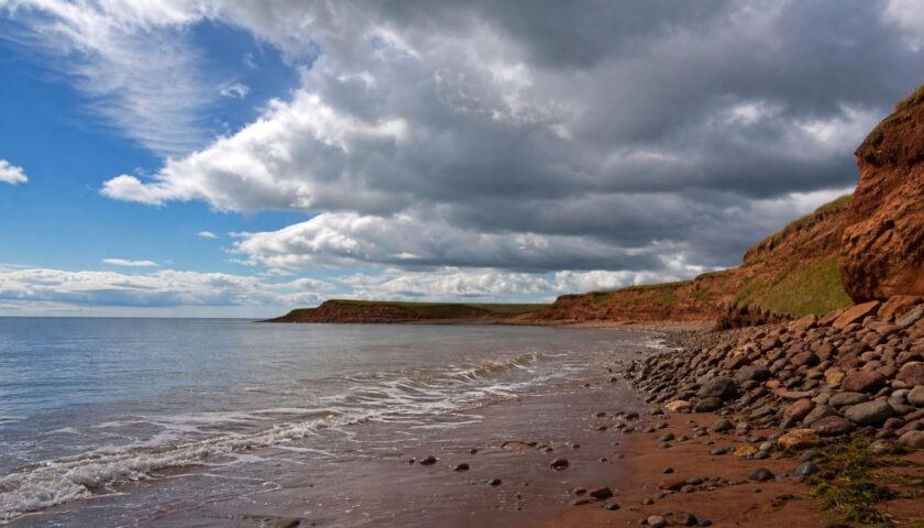
North shore: Exposed to the Gulf, the north shore catches prevailing westerlies and summer sea breezes. On a hot day, beaches in the PEI National Park can run several degrees cooler than inland towns. Surf and swell are more likely here, and coastal fog on warm-over-cold setups can briefly cut visibility. In winter, open areas are more prone to blowing and drifting snow.
South shore: The Northumberland Strait is shallower and warms quickly. Sheltered coves can feel toasty in late summer with lighter chop. On strong south winds, the south shore runs cooler by day. In spring, this shore can lose sea ice earlier than the north coast, affecting when lobster boats and ferries resume certain operations.
Charlottetown and inland: Urban heat effects are modest but noticeable—streets and roofs soak and release heat, bumping overnight lows a degree or two compared to rural areas. Storms that cross PEI often intensify along coastal convergence zones; occasionally Charlottetown stays dry while the coast showers, or vice versa. For runners and cyclists, inland winds can be less gusty than at the beach, but line up a loop with wind direction or you’ll fight the breeze home.
Western versus eastern PEI: The Island stretches enough east–west that timing of frontal passages can differ by an hour or two. The western tip (North Cape) is famously windy, a draw for wind energy research. The east end (near East Point) often catches first light and first fog as ocean air flows in overnight.
Storms, Alerts, and How to Prepare on the Island
When Islanders say “It’s coming on,” they mean a system is moving in and plans should flex. Knowing what ECCC alerts mean helps you act early.
Understanding Canadian Weather Alerts
- Special Weather Statement: Heads-up for potentially impactful conditions that aren’t yet certain or may not meet warning criteria. On PEI this often precedes snow events or strong wind setups.
- Warnings (Snowfall, Wind, Freezing Rain, Rainfall): Issued when impacts are likely and criteria are expected to be met. For example, snowfall warnings generally align with significant accumulations in a short period, and wind warnings with damaging gusts. Exact thresholds can vary by region and evolve with ECCC guidelines.
- Blizzard Warning: Reduced visibility in blowing or falling snow, strong winds, and dangerous wind chills for several hours. Travel should be delayed or avoided.
- Storm Surge/Coastal Flooding Statement or Warning: Elevated water levels and waves threatening coastal areas during strong storms or post-tropical systems.
- Heat and Humidex Advisories: On rare hot spells, advisories flag health risks and suggest cooling strategies.
Check the forecast twice before a known storm: once 48–72 hours out to plan, and again the evening prior for latest track and timing. Coastal residents, cottage owners, and anyone with boats ashore should pay special attention to wind direction and surge risk. Storms that push water toward shallow bays can flood low-lying properties even when rain amounts are moderate.
Nor’easters, Blizzard Setups, and Freezing Rain
Nor’easters are classic Atlantic Canada systems. They draw moisture up the U.S. eastern seaboard and slam into cold air entrenched over the Maritimes. The dividing line between heavy snow and a messy mix often runs across the Island; a small track shift means the difference between two shovellings and a roof rake for the deck. PEI can also experience prolonged freezing rain when warm air rides over a shallow sub-freezing layer—lines glaze, branches bend, and roads become rinks. Sand and salt crews move fast, but rural stretches can take time to catch up, especially overnight.
In blizzard setups, visibility drops below a few hundred metres in blowing snow and winds can gust well past safe thresholds for high-sided vehicles. The Confederation Bridge sometimes restricts or escorts certain vehicle types during high winds for safety. If you’re planning a crossing in winter or during a wind event, check advisories ahead of departure rather than rolling up to the tolls and hoping for the best.
Hurricanes and Post-Tropical Storms
From late August through October, PEI watches the tropics. Most storms recurve or weaken, but some arrive as potent post-tropical systems with broad wind fields, heavy rain, and long-duration pounding surf. The memorable case in recent years is Fiona (September 2022), which delivered extreme winds, toppled trees, carved beaches, and left widespread power outages. Lessons from events like Fiona are simple: secure outdoor items, trim trees away from roofs, have a 72-hour emergency kit, and never run generators indoors or in attached garages—carbon monoxide kills silently and quickly.
Follow ECCC tropical statements and local emergency messaging. If you’re on a coastal site in a travel trailer, identify a sturdier shelter before the storm. Park vehicles on higher ground away from trees. If you own coastal property, understand your site’s exposure and elevation; insurers will expect reasonable mitigation, and municipalities may issue pre-storm guidance for flood-prone roads.
Power Outages and Recovery
Outages can happen in any season, from ice and snow in winter to treefall in summer squalls. Practical basics help:
- Store extra water and non-perishables; plan for three days minimum.
- Keep phone chargers and a battery bank handy; car chargers can keep essentials alive.
- Use candles with caution; flashlights and headlamps are safer. If you must use a generator, choose a CSA-approved unit, site it outdoors and away from vents, and use proper transfer switches to avoid backfeeding lines.
- Freezers stay safe if unopened for roughly 24–48 hours, fridges for about 4 hours; dry ice can extend that window.
- Maritime Electric shares restoration estimates during major events; patience helps crews work safely with winds and ice.
Practical Tips for Travellers and New Residents
What to Pack for PEI
PEI weather rewards layers and sensible footwear. The Island’s wind makes clothing choices more about fabric and function than raw temperature.
- Winter (Dec–Feb): Insulated, windproof jacket; warm mid-layer (fleece or wool); thermal base layer on cold snaps; toque; mitts; insulated boots with good tread; ice grippers for rural walking; car kit with blanket and shovel if you drive.
- Spring (Mar–May): Waterproof jacket and footwear; light gloves and toque for chilly mornings; warm sweater; quick-dry pants (mud and puddles); sunglasses—sun on snow is bright.
- Summer (Jun–Aug): Light layers, shorts, breathable shirts; sun hat; sunglasses; high-SPF sunscreen; packable fleece or hoodie for evenings; sturdy sandals or water shoes for rocky entries; bug spray, especially in June.
- Fall (Sep–Nov): Warm layers; rain shell; hat; waterproof boots for farm visits and trails; gloves by late October.
Driving and Getting Around
- Winter tires: Not legally required in PEI (unlike Quebec), but they’re the norm and strongly recommended from November through April. All-season tires harden in the cold and can’t match winter compounds on ice.
- Confederation Bridge: Crossings can be restricted for high-sided vehicles during strong winds; check advisories before you go. Black ice is possible near the approaches in cold, damp conditions.
- Northumberland Ferries: The Wood Islands–Caribou ferry typically operates seasonally and can be delayed by strong winds, heavy seas, or ice near shoulder seasons. If timing is tight, build in a buffer or plan to use the bridge.
- 511 and road reports: The province provides road condition updates; after major storms, rural secondary roads may take longer to clear and can drift shut in open fields.
- Visibility: Sea fog can drop fast, especially in late spring and summer mornings. Use headlights (not just DRLs) and keep speed moderate; deer are present island-wide.
Health, Comfort, and Common-Sense Weather Habits
- UV index: Don’t underestimate it. Even at 22°C with a breeze, you can burn in under an hour in July.
- Wind: Look at gust forecasts, not just sustained speeds. A day with sustained 25 km/h and gusts 45 km/h feels very different than a steady 25.
- Allergies: Tree pollen emerges in spring; grasses in early summer; ragweed late summer into fall. Rain often brings short-term relief; dry, breezy days lift pollen counts.
- Mosquitoes and blackflies: Worse in early summer near wetlands, calmer on breezy beaches. A simple head net earns its keep when hiking through spruce in June.
Beach Days, Wind, and Water on PEI
Let’s decode the classic PEI beach puzzle: which beach today? Start with wind direction and recent weather. Two examples:
- Hot and calm morning, light southwest breeze building: South-shore beaches can feel warmer, with minimal surf. By early afternoon, a gentle onshore sea breeze cools both coasts slightly.
- North wind after a cold front: North-shore beaches can be cooler and choppier, great for wave play if you’ve brought a warmer top; south shore offers a lee and warmer feel.
Rip currents happen when breaking waves push water toward shore and it escapes through channels back out. North-shore sandbars shift season to season. Swim at lifeguarded beaches in PEI National Park during the season, heed flag systems, and keep kids within arm’s reach. Late summer can bring jellyfish, primarily lion’s mane; stings are uncomfortable but typically mild. Rinse with seawater first, not freshwater, to avoid firing undischarged nematocysts, and seek lifeguard advice if available.
Kayakers and paddleboarders should watch for offshore winds—an easy paddle out becomes hard work returning. File a simple float plan with a friend, carry a whistle, PFD, and a way to call for help. Water can feel warm at the surface while deeper layers remain cool; hypothermia remains a risk in shoulder seasons.
Agriculture, Fisheries, and Working with the Weather
PEI’s economy runs on schedules tied to sky and sea. Farmers, fishers, and construction crews all watch forecasts, but in different ways.
Farming and Frost Windows
Potatoes dominate many fields, joined by grains, forages, and vegetables. Typical planting runs May into June, when soil temperatures rise and the risk of a hard frost fades. Late spring frosts can still catch early plantings or tender crops in low-lying pockets. Row covers and irrigation for frost protection see use on high-value crops like strawberries. Summer rain is a balancing act: too much and fields compact; too little and tuber bulking suffers. Drought summers are not unheard of; some farms have adopted irrigation and water management plans to cope.
Harvest peaks September to October. A run of dry, cool days is prized—mud is the enemy of efficient harvest. Wet October weather pushes work into tighter windows and can stress storage logistics. Freeze-up of topsoil in late fall can be either a blessing (firm footing) or a problem (if it extends before fields are cleared).
Fishing Seasons and Marine Weather
Commercial fisheries on PEI, including lobster, operate under seasons and zones set by Fisheries and Oceans Canada. Spring and fall openings differ by area, but weather shapes day-to-day decisions: wind over tide can stack steep waves in the Strait, fog can slow departures, and early or late-season sea ice can complicate gear handling. Freezing spray—when cold wind whips seawater onto vessels and it freezes on contact—is a serious hazard in winter on open water; mariners monitor marine forecasts, freezing spray bulletins, and air–sea temperature spreads carefully.
Recreational boaters should study local charts and watch for sandbars that shift after storms. After significant events, inlets can shoal in unexpected spots. Always carry proper safety gear and file a float plan, even on short runs. The Canadian Coast Guard and local volunteer ground search and rescue groups appreciate accurate information if something goes sideways.
Climate Trends and Change on PEI
Atlantic Canada is already feeling climate change in ways that matter day to day. Long-term datasets from Environment and Climate Change Canada and the Government of PEI show several consistent themes:
- Warmer winters: Fewer extreme cold snaps and more freeze–thaw cycles. This can mean more winter rain and freezing rain, with associated ice risks and road maintenance challenges.
- Less reliable sea ice: Shorter duration and reduced extent of Gulf ice reduces natural shoreline protection in winter, contributing to greater wave attack during storms.
- Heavier downpours: When it rains, it can pour. Infrastructure—ditches, culverts, urban drains—faces higher peak flows, raising flood and erosion risks.
- Hotter summer days: Heat alerts are still less common than in central Canada, but warmer nights and occasional multi-day heat events are more likely than they were decades ago.
- Sea level rise: Relative sea level is rising along PEI’s coast, influenced by global ocean expansion and regional land subsidence. Projections point to continued rise through the century, with implications for wharves, coastal roads, and low-lying communities.
Adaptation is underway. Municipal planning now pays closer attention to setbacks and elevations for coastal development. Shoreline stabilization projects favour living shorelines and dune restoration where feasible. After major storms, beach access points and park infrastructure are rebuilt with higher design standards. Residents elevate heat pumps and backup power systems, trim and diversify tree cover, and keep emergency kits as a normal household item. For your own planning, factor in resilience: choose roofing that holds in high wind, install proper backflow prevention if you live in a flood-prone zone, and document belongings for insurance ahead of hurricane season.
Reading a PEI Forecast Like a Local
Forecasts are only as good as your ability to translate them into action. Here’s how Islanders read between the lines:
- “Chance of showers” in summer: Expect a quick-moving cell with a downpour and sunshine fifteen minutes later. Keep a small umbrella and carry on.
- Wind direction matters: A 24°C forecast feels different with a north wind on the north shore (cooler at the beach) than with a southwest wind (warm, gentle surf).
- Watch the timing window: If a nor’easter is “late day into overnight,” finish errands by mid-afternoon. Rural snow clearing prioritizes arterials first; side roads can wait until winds ease.
- Bridge advisories: High wind and freezing spray warnings don’t mean the Confederation Bridge will close for everyone, but certain vehicles can face restrictions or escorts. Confirm before you commit.
- Marine layer mornings: Fog often burns off by late morning with sun and a light breeze. If you’re shooting photos at sunrise on the north shore, build in a day or two so you can pivot to an inland trail if fog sticks.
Charlottetown, Summerside, and Beyond: City-to-Coast Comparisons
Charlottetown sits on a harbour that can trap fog on still summer mornings and funnel breezes on hot afternoons. Its urban core runs a touch warmer at night than sprawling rural areas, but daytime highs are similar to nearby communities. Summerside, on the south shore, often enjoys slightly earlier warm-water days thanks to the Strait’s quick warming, while North Rustico and Cavendish along the north shore catch more sea breeze—and more swell after prolonged winds.
Venture toward East Point and you’ll meet faster weather changes. Systems often reinvent themselves at the tip, shifting wind angles and cloud streets in a way kite surfers and sailors learn to love. The west end, around Tignish and North Cape, is wind country; it’s no accident that wind turbines stud the horizon there.
Events, Festivals, and the Weather Windows That Suit Them
Planning around PEI weather makes events smoother and more enjoyable:
- Spring marathons and bike rides: Aim for late May to early June for milder temps and lower wind risks than April.
- Beach-heavy vacations: Late July and August guarantee the warmest water. Book early, and schedule flexible beach vs. inland days depending on wind direction.
- Photography trips: September offers warm water, vivid skies, and wild sunsets. Cooler air over warm Gulf water can create dramatic cloudscapes post-front.
- Fall harvest visits: Late September through mid-October balances colour with decent hiking weather. Pack a rain layer and waterproof boots.
- Winter quiet retreats: January and February bring serene snowy scenes. Choose accommodations with backup heat or wood stoves, and enjoy trails when conditions permit.
Safety Checklists for Common PEI Weather Scenarios
Winter Storm Day
- Before: Top up fuel, charge phones, pick up groceries, move vehicles off the street to help plows.
- During: Avoid non-essential travel. If you must drive, carry a shovel, traction aids, and warm gear. Keep your tailpipe clear if stuck.
- After: Shovel in stages to avoid overexertion; roof rake safely from the ground if wet snow piles up near eaves.
Hot Summer Day with Sea Breeze
- Before: Hydrate, plan for mid-day shade, sunscreen early and often.
- During: Choose a beach with an onshore breeze for natural AC; keep an eye on tide if you’re on long sand spits.
- After: Pack a warm top for the evening; temps dip quickly after sunset by the water.
Post-Tropical Storm Watch
- Before: Secure or store outdoor furniture, trim loose branches, move boats to safe storage, and assemble your 72-hour kit.
- During: Shelter in a sturdy building, stay away from shorelines during peak winds and surge, and avoid downed lines.
- After: Photograph damage before cleanup for insurance, check on neighbours, and manage food safety for fridges/freezers.
Common Questions About PEI Weather
Is PEI weather milder than the rest of Atlantic Canada?
Compared to the Bay of Fundy coast in New Brunswick or Nova Scotia, PEI generally sees less persistent fog and more comfortable summer humidity. Winters are cold and snowy, but the Island often avoids the extreme deep freezes found inland on the Prairies. It’s still Atlantic Canada—stormy spells come with the territory.
When is the best time to visit for beaches?
Late July through August offers the warmest ocean temperatures and the longest run of true beach days. September is a superb shoulder month—warm water, pleasant air, fewer crowds—though tropical remnants can bring a wet, windy day or two.
Does PEI get hurricanes?
It sees the remnants and post-tropical versions of hurricanes more often than direct hits from tropical systems. Those post-tropical storms can still be powerful, with damaging winds, heavy rain, and storm surge. Local authorities and ECCC issue clear guidance when one is on the way.
How bad are winters? Will I need a snowblower?
Snowfall is significant most winters. If you have a long driveway or limited time, a snowblower is a smart investment. In-town lots can often be managed with a shovel, but wet snows and back-to-back events can make it tough. Many residents hire plowing services for the season.
Is fog common on PEI?
It occurs, but it’s not usually as tenacious as along the Fundy coast. Spring and early summer see the most near the shoreline on warm days over cold water. Inland, fog is less frequent and tends to burn off by late morning.
Do I need winter tires in PEI?
They’re not required by law, but strongly recommended. Performance and safety improve dramatically on snow and ice compared to all-seasons.
How often does the Confederation Bridge close for weather?
Full closures are rare. More commonly, restrictions or escorts apply to high-sided vehicles during high winds or icy conditions. It’s wise to check advisories before setting out during stormy weather.
What’s the UV like in summer?
Strong. Even on days in the low 20s with a breeze, UV can reach high. Sunscreen, sunglasses, and hats are part of a normal beach kit.
What should I watch for with PEI’s changing climate?
Heavier downpours, more freeze–thaw, reduced sea ice in winter, and rising sea levels. Expect more emphasis on flood-aware home upgrades, tree maintenance, and storm prep—smart moves regardless of projections.
Are there tornadoes on PEI?
They’re rare and typically weak in Atlantic Canada compared to central regions. Severe thunderstorms can still bring strong wind gusts and lightning; monitor ECCC alerts on stormy days.
Final Thoughts: Making Friends with PEI Weather
PEI weather asks you to pay attention. In return, it gives you variety: a blustery north-shore walk that ends with hot chowder, a July afternoon that slides from beach blanket to hoodie and stars, and a September day where warm water and crisp air meet. Pack layers, watch the wind, respect the sea, and keep a flexible plan. Do that, and the Island’s weather becomes an ally—one that makes every day a little more interesting.